[Note: this is a back-dated blog entry, posted in September 2014, to document the events of the station swap-out that led to a moratorium on climbing this station.]
In the week of May 26th - 30th, AOMLers Ian Enochs and Mike Jankulak traveled to St. Croix, USVI, with C-ARMS contractor Jon Fajans for work at the CREWS station near Salt River Bay on the north coast of the island. There were four goals: swap out all instruments on the station, install a new cellular modem to improve station communications, deploy a number of NCRMP (National Coral Reef Monitoring Program) experiments, and train Jon Fajans as a fully-redundant backup for Mike Jankulak's station-climbing activities.
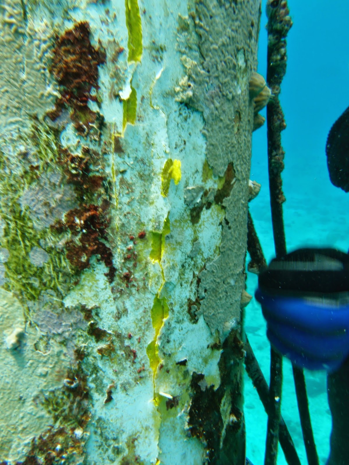
These activities were interrupted by the unexpected and catastrophic failure of a RDI/Teledyne CTD within 24 hours of its deployment. The CTD is believed to have exploded due to an internal buildup of gasses from its batteries, although the exact cause of the malfunction is not yet understood. This explosion was witnessed by the team Wednesday morning and the resulting structural damage to the fiberglass pylon was documented in photos. A decision was made to cut short all work on the station until the structure could be reevaluated for its fitness to climb, leaving the station with a mixture of instruments (four new, four old, three missing) and with key elements of the training exercise incomplete. Although the station was left on Wednesday in a functional state, two days later it ran out of power because its solar panels were not correctly charging its batteries.
On the plus side, the NCRMP activities led by Ian Enochs resulted in the successfully deployment of three autonomous reef monitoring structures (ARMS), five calcification accretion units (CAUs) and five bioerosion monitoring units (BMUs). On the CREWS side, the team was able to recover six months of station data that had not been expected to exist, following the station's apparent loss of power and cessation of communications in December of 2013, which considerably extends the data coverage at this site.
Three photos of the CTD and station, post-explosion, follow (photo credit: Ian Enochs). Clicking on any of these photos will load the original, larger version of the image file.
(signed) Mike Jankulak
This site is for providing Salt River ICON/CREWS field maintenance records for NOAA/AOML/ICON data management purposes. Please update this blog whenever new operations are performed in the field, so that AOML can coordinate their efforts with the Salt River ICON/CREWS field efforts.
Friday, May 30, 2014
Wednesday, May 21, 2014
Upcoming CREWS Swapout
In the week of May 26th - 30th a team from AOML will be visiting the CREWS station in St. Croix, USVI, that is located off the north coast of the island near Salt River Bay. AOML's Ian Enochs and Mike Jankulak will be traveling to St. Croix, and contractor Jon Fajans will be joining them to receive training in station maintenance procedures.
The station has been offline since last December, and on this trip the station will be outfitted with a digital cellular modem to replace its GOES transmitter. This will give AOML 24x7, instantaneous access to the station's complete data collection, as compared to the once-per-hour, 20-second, low-baud-rate GOES window used previously. Data collection at this site by CREWS dates back to June of 2002.
This station is also a monitored site in NCRMP (the National Coral Reef Monitoring Program). In service of this program, and as part of a collaboration with CRED (NOAA's Coral Reef Ecosystem Division in Hawai`i), the team will be installing ARMS (autonomous reef monitoring structures), CAUs (calcification accretion units) and BMUs (bioerosion monitoring units) to join the STRs (subsurface temperature recorders) that are already in place at the site.
(signed)
Mike Jankulak
The station has been offline since last December, and on this trip the station will be outfitted with a digital cellular modem to replace its GOES transmitter. This will give AOML 24x7, instantaneous access to the station's complete data collection, as compared to the once-per-hour, 20-second, low-baud-rate GOES window used previously. Data collection at this site by CREWS dates back to June of 2002.
This station is also a monitored site in NCRMP (the National Coral Reef Monitoring Program). In service of this program, and as part of a collaboration with CRED (NOAA's Coral Reef Ecosystem Division in Hawai`i), the team will be installing ARMS (autonomous reef monitoring structures), CAUs (calcification accretion units) and BMUs (bioerosion monitoring units) to join the STRs (subsurface temperature recorders) that are already in place at the site.
(signed)
Mike Jankulak
Wednesday, April 16, 2014
Lightning Strike or Not? Photo Analysis
[n.b. This is a backdated post, part of a May/2014 blog catchup.
This post's content is a slightly edited version of an email sent on
April 16th, 2014, about our analysis of recent photos of the station and whether they supported the theory that a lightning strike had been the cause of the station's December communications failure.]
Thanks very much for sending photos! A picture really is worth a thousand words. I've looked over those six photos very carefully and my armchair-quarterbacking opinion is that there isn't any evidence of lightning damage, at least nothing observable from these photos.
Just to refresh everyone's memories, here is your Feb 26th report:
Begging everyone's patience, here is my analysis of the state of the aerial instruments as shown in these photos. I am attaching a copy of your 008 photo that I've scribbled on to identify which instruments I'm talking about, which might help.
There are four bright white objects at the top of the station -- BIC (light sensor), WXT (integrated wind/weather transmitter), windbird (anemometer) and GOES antenna. The air temp in its radiation shield is also up there but somewhat lower down than the others.
I don't see any "blackened burn marks" on any of these, at least not visible in these photos. The closest to a black mark is on the BIC, on its S/SE side, visible from photos 007, 008, 009 and 017 (the side showing in photos 010 and 015 appears to be completely white). Here you can see the BIC's logo/label (see attached closeup photo of the BIC on my workbench) on the upper side. Also there appears to be some rust stains, orange/brown, below this, probably from the hose clamps that are holding the BIC to the aluminum mast. Some may recall that when we were there last August the BIC I'd brought with me was found to be dead on arrival, so I simply reattached the same BIC that had been there since 2011. So this same instrument has now been out there for almost 3 years.
The windbird and the GOES antenna, as far as I can tell, are completely white.
The WXT too shows no signs of discoloration. At first I thought photo 007 might show that one of its three protruding acoustic wind sensors is bent or broken. Looking more closely though I think I'm just seeing one of the think metal bird spikes, slightly bent, and a little blurriness is making it look thicker than it really is.
Finally the lightning diffuser brush looks pretty good to me for its age, about the same as I remember (see attached photo from last August). Note that this is not a lightnight "rod", i.e. its purpose is not to attract lightning. Rather it is a diffuser, and when properly grounded it serves to "hide" the whole station from lightning activity and make it "appear" to the clouds as though it's just a stretch of featureless ocean. This lightning diffuser actually looks a lot healthier than the one at our Puerto Rico station, which has been under constant mistreatment by boobies.
Anyhow, please speak up if you feel like there is something in these photos that I'm missing, or if you believe that there are further signs of lightning damage at the station that aren't well represented in these photos. But for now I am going to tentatively (and happily) conclude that a direct strike by lightning did not occur.
Naturally we will plan this next visit, as much as possible, to arrive carrying everything we would need to repair the station following an actual lightning strike. Better to be as prepared as possible.
(signed)
Mike Jankulak
Thanks very much for sending photos! A picture really is worth a thousand words. I've looked over those six photos very carefully and my armchair-quarterbacking opinion is that there isn't any evidence of lightning damage, at least nothing observable from these photos.
Just to refresh everyone's memories, here is your Feb 26th report:
There must have been a large lightning strike, a couple of instruments at the top of the pylon showed blackened burn marks, and the lighting rod looked toasted, so we are assuming that a massive strike may have taken place.
Begging everyone's patience, here is my analysis of the state of the aerial instruments as shown in these photos. I am attaching a copy of your 008 photo that I've scribbled on to identify which instruments I'm talking about, which might help.
![]() |
| Marlon's photo as marked up by Mike Jankulak. Click on the photo to see a larger version. |
There are four bright white objects at the top of the station -- BIC (light sensor), WXT (integrated wind/weather transmitter), windbird (anemometer) and GOES antenna. The air temp in its radiation shield is also up there but somewhat lower down than the others.
I don't see any "blackened burn marks" on any of these, at least not visible in these photos. The closest to a black mark is on the BIC, on its S/SE side, visible from photos 007, 008, 009 and 017 (the side showing in photos 010 and 015 appears to be completely white). Here you can see the BIC's logo/label (see attached closeup photo of the BIC on my workbench) on the upper side. Also there appears to be some rust stains, orange/brown, below this, probably from the hose clamps that are holding the BIC to the aluminum mast. Some may recall that when we were there last August the BIC I'd brought with me was found to be dead on arrival, so I simply reattached the same BIC that had been there since 2011. So this same instrument has now been out there for almost 3 years.
| A closeup of a Surface BIC on my workbench, showing its label/logo. Click on this photo to see a larger version. |
The windbird and the GOES antenna, as far as I can tell, are completely white.
The WXT too shows no signs of discoloration. At first I thought photo 007 might show that one of its three protruding acoustic wind sensors is bent or broken. Looking more closely though I think I'm just seeing one of the think metal bird spikes, slightly bent, and a little blurriness is making it look thicker than it really is.
Finally the lightning diffuser brush looks pretty good to me for its age, about the same as I remember (see attached photo from last August). Note that this is not a lightnight "rod", i.e. its purpose is not to attract lightning. Rather it is a diffuser, and when properly grounded it serves to "hide" the whole station from lightning activity and make it "appear" to the clouds as though it's just a stretch of featureless ocean. This lightning diffuser actually looks a lot healthier than the one at our Puerto Rico station, which has been under constant mistreatment by boobies.
| Mike Jankulak in August of 2013, including a view of the station's lightning diffuser brush. Click on this photo to see a larger version. |
Anyhow, please speak up if you feel like there is something in these photos that I'm missing, or if you believe that there are further signs of lightning damage at the station that aren't well represented in these photos. But for now I am going to tentatively (and happily) conclude that a direct strike by lightning did not occur.
Naturally we will plan this next visit, as much as possible, to arrive carrying everything we would need to repair the station following an actual lightning strike. Better to be as prepared as possible.
(signed)
Mike Jankulak
Thursday, December 05, 2013
Station Offline, NCRMP Sensors
[n.b. This is a backdated post, part of a May/2014 blog catchup.
This post's content is based in part on an email composed on December 5th, 2013, and also describes the station's complete failure of communications that had occurred a few days earlier.]
Marlon Hibbert and José Sanchez visited the CREWS station on December 3rd, 2013. In the wake of that visit Marlon wrote me with questions about two instruments that were found in the vicinity of the station, instruments that he had not previously noticed. One was said to be attached to the station's support chains and labeled #1254 and the other was close to a coral head to the west of the station, labeled #1258.
These standalone or "hobo" temperature sensors were not directly related to the CREWS (Coral Reef Early Warning System) program, but were part of AOML's larger CHAMP (Coral Health and Monitoring Program) activities. Another of our operations is under the auspices of NCRMP (National Coral Reef Monitoring Program) which monitors a large number of sites at coral reef ecosystems throughout the Gulf of Mexico, Coastal Florida, the Caribbean and the world. In this case the NCRMP team had deployed some new sensors at the station site without keeping the CREWS team in the loop, and so our local colleagues could not be alerted to these developments beforehand. I thanked Marlon for his report and assured him that the sensors were part of NOAA operations.
In more serious news, the station has ceased communications completely as of December 1st, 2013. There is no obvious explanation for this failure, so we are left with the usual possibilities, which mainly involve various types of power failure or a GOES transmitter failure. It does not seem likely that the problem stems from a flooded instrument because usually we see at least a few hours of sharply dropping voltage reports when that happens. But given the power problems we've seen to one degree or another dating back to November of 2012, this failure of communications does not come as a complete surprise.
As resolved last August, on our next visit we will attempt to fix the power problem by installing new batteries. This next trip is expected to take place in early-to-mid 2014.
(signed)
Mike Jankulak
Marlon Hibbert and José Sanchez visited the CREWS station on December 3rd, 2013. In the wake of that visit Marlon wrote me with questions about two instruments that were found in the vicinity of the station, instruments that he had not previously noticed. One was said to be attached to the station's support chains and labeled #1254 and the other was close to a coral head to the west of the station, labeled #1258.
These standalone or "hobo" temperature sensors were not directly related to the CREWS (Coral Reef Early Warning System) program, but were part of AOML's larger CHAMP (Coral Health and Monitoring Program) activities. Another of our operations is under the auspices of NCRMP (National Coral Reef Monitoring Program) which monitors a large number of sites at coral reef ecosystems throughout the Gulf of Mexico, Coastal Florida, the Caribbean and the world. In this case the NCRMP team had deployed some new sensors at the station site without keeping the CREWS team in the loop, and so our local colleagues could not be alerted to these developments beforehand. I thanked Marlon for his report and assured him that the sensors were part of NOAA operations.
In more serious news, the station has ceased communications completely as of December 1st, 2013. There is no obvious explanation for this failure, so we are left with the usual possibilities, which mainly involve various types of power failure or a GOES transmitter failure. It does not seem likely that the problem stems from a flooded instrument because usually we see at least a few hours of sharply dropping voltage reports when that happens. But given the power problems we've seen to one degree or another dating back to November of 2012, this failure of communications does not come as a complete surprise.
As resolved last August, on our next visit we will attempt to fix the power problem by installing new batteries. This next trip is expected to take place in early-to-mid 2014.
(signed)
Mike Jankulak
Wednesday, December 04, 2013
Cleaning and calibration
On December 3rd, 2013 Park Ranger Jose Sanchez and Marlon Hibbert visited the station to perform needed calibration and cleaning. It was the second visit since the team from AOML visited in early August.
For the months of October and November no visits were accomplished due to either the weather or other unavoidable delays.
That said , the station appeared in fair condition. Due to the weather, we had the opportunity to clean the topside of the pylon, normally it is near impossible to work at the top due to surge. The screens on the lower CTD were also changed.
The calibration begun @ approximately 1000 hrs and terminated @ 1400hrs.
Our next trip is planned for a few weeks time, before years end and contingent on weather conditions.
For the months of October and November no visits were accomplished due to either the weather or other unavoidable delays.
![]() |
| Conditions good |
That said , the station appeared in fair condition. Due to the weather, we had the opportunity to clean the topside of the pylon, normally it is near impossible to work at the top due to surge. The screens on the lower CTD were also changed.
The calibration begun @ approximately 1000 hrs and terminated @ 1400hrs.
Our next trip is planned for a few weeks time, before years end and contingent on weather conditions.
![]() |
| Jose at work on the chains |
![]() |
| Before cleaning |
![]() |
| After cleaning |
A maintenance trip was planned and conducted on June 13, 2013. This was the first site visit since mid March due to logistics of getting to the site and poor weather conditions.
Park Interpretative Ranger ( Jose Sanchez) and Coral fellow ( Jenn Travis) assisted topside by Marlon Hibbert carried out routine cleaning of the station. Conditions were not conducive to attaching the CTD for calibration as wave conditions made it unsafe for the boat to pull alongside the stick.
Instead the team decided to that they would concentrate efforts on the bottom portions of the pylon. The top half of pylon has proven difficult to maintain and and can only be done in the calmest of weather as the surge and risk of injury is highest with increased wave action.
That said, Jose and Jenn did a great job in the time they spent, but reported coming back feeling as if they had been dragged along behind a bus , such were the conditions.
Park Interpretative Ranger ( Jose Sanchez) and Coral fellow ( Jenn Travis) assisted topside by Marlon Hibbert carried out routine cleaning of the station. Conditions were not conducive to attaching the CTD for calibration as wave conditions made it unsafe for the boat to pull alongside the stick.
Instead the team decided to that they would concentrate efforts on the bottom portions of the pylon. The top half of pylon has proven difficult to maintain and and can only be done in the calmest of weather as the surge and risk of injury is highest with increased wave action.
That said, Jose and Jenn did a great job in the time they spent, but reported coming back feeling as if they had been dragged along behind a bus , such were the conditions.
Monday, October 21, 2013
Missing CTD located in Utah
[n.b. This is a backdated post, part of a May/2014 blog catchup.
This post's content is based on email updates I wrote when FedEx located the CTD that we'd attempted to ship to St. Croix in August.]
Following the resumption of normal activities after the US Government shutdown, I was put into touch with a NOAA employee whose role it was to act as liaison (and arbiter, in case of problems) between NOAA and FedEx. She was able to accomplish within a few days what I'd been unable to do in two months: get FedEx to look for the missing package. And they found it! It was found in some sort of waystation for lost items in Utah.
Initially I told them to just send it on its way to St. Croix as originally planned, but I thought the better of it and asked them to ship it back to me in Miami. I figured I should reevaluate the CTD and make sure it hadn't suffered any damage during its two-month journey from Memphis to Utah.
As of this writing (late October) the plan is to evaluate the CTD and then send it (or another) on to St. Croix so that the Shallow CTD can be replaced as originally planned last August.
(signed)
Mike Jankulak
Following the resumption of normal activities after the US Government shutdown, I was put into touch with a NOAA employee whose role it was to act as liaison (and arbiter, in case of problems) between NOAA and FedEx. She was able to accomplish within a few days what I'd been unable to do in two months: get FedEx to look for the missing package. And they found it! It was found in some sort of waystation for lost items in Utah.
Initially I told them to just send it on its way to St. Croix as originally planned, but I thought the better of it and asked them to ship it back to me in Miami. I figured I should reevaluate the CTD and make sure it hadn't suffered any damage during its two-month journey from Memphis to Utah.
As of this writing (late October) the plan is to evaluate the CTD and then send it (or another) on to St. Croix so that the Shallow CTD can be replaced as originally planned last August.
(signed)
Mike Jankulak
Subscribe to:
Posts (Atom)